
Geospatial Monitoring
Home / Geospatial Monitoring
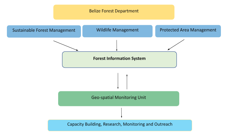
The Geospatial Monitoring Unit (GSMU) was established to support forest resources management by monitoring and conducting spatiotemporal analysis, applied research, education, and reporting in the areas of land use and land use change, sustainable forest management and protected areas management, and wildlife conservation in Belize.
Unit goal: To contribute towards the generation of national forest statistical and spatiotemporal information to guide decision making in areas of areas of land use and land use change, sustainable forest management and protected areas management, and wildlife conservation.
Responsibilities:
- Collect activity and land use/landcover data
- Provide Land Use/Land cover Information
- Lead the preparation of National Reports such as the Land Use Change Forest Green House Inventory and REDD+ Reference level data
- Support data collection and analysis and present information on forest monitoring wildland fires and pest management
- Organize and lead trainings on the use of Drones, Geographic Information System and Remote Sensing technology and their application in forest management and relevant fields.
Activities:
- Development of Land use/Land cover map (2000-2018) using Collect Earth Desktop – This classification contributes to the generation of the Forest Reference Level for Belize which is essential in REDD+ framework and carbon trading. This work is made possible through Geospatial Technology including Geographic Information System, Google Earth Engine, and other remote sensing software. To date the Unit has collected and analyzed information on land use and land use change and forest cover for the period 2000-2019 and will continue to update on an annual basis.
- Development of a National Green House Gas Inventory Tool for the forest sector and REDD+ Reference Level Data – The collection of activity data or Landuse/Landcover data is guided by the Intergovernmental Panel on Climate Change Guidelines (Forest, Cropland, Grasslands, Wetlands, Settlements, and Other Lands). The analysis and interpretation of the Landuse/Landcover data has led to the development of a National Green House Gas Inventory Tool for the Forest Sector, the submission of the first Forest Reference Level of Belize to the UNFCCC, and the Belize National Forest Monitoring System (NFMS).
- Development of Belize’s first Forest Reference Level Report to the UNFCCC
- Development of the Belize National Forest Monitoring System (NFMS)
- Monitoring and surveillance in key protected areas- Through the GIZ Selva Maya IUCN KfW project, targeted overflights in key protected areas have been conducted across Belize. Overflights assist in the detection of transboundary incursions, encroachments and other anthropogenic activities which may threaten the natural integrity of the national protected areas system.
- Monitoring and mapping wildland fire hotspots across the country– The GSMU uses online platforms on fires and heat signatures such as NASA FIRMs and CONABIO to detect heat points and monitor hotspots, especially in the Mountain Pine Ridge Forest Reserve. Drone technology is used in the monitoring of wildland fires.
- Mapping of sawmills and carpentry/wood workshops
As part of a national effort to address illegal logging and associated activities, measures are being adopted to prevent the trade of illegal timber products. The management and control of the supply chain from harvesting to processing, domestic sales, exports, and imports warrants a systematic tracking system. Belize has in place transport documents (waybills) and property brands for logs being transported from the forest to a sawmill. The timber industry uses sawmills for the conversion of logs to lumber and these mills are spread across the country. The Unit has been able to register the timber processing facilities at the national level using facilitating enforcement activities.
Mapping of areas in the Mountain Pine Ridge Forest Reserve affected by Bark Beetle (Dendroctonus frontalis)- Since the early 2000’s, the pine forests of Belize have been impacted by the infestation of the Southern Pine Bark Beetle. Though the effects today may not be as adverse as in previous years, the threat and impacts of this pest continues to be present in the Mountain Pine Ridge Forest Reserve. The GSMU uses drone technology to examine, assess and understand the extent and spread of the Southern Pine Bark Beetle Infestation in the Mountain Pine Ridge Forest Reserve.